 "itschrome" (itschrome)
09/05/2018 at 10:44 • Filed to: None
 0
0
 24
24|
"itschrome" (itschrome)
09/05/2018 at 10:44 • Filed to: None | 0
| 24 |
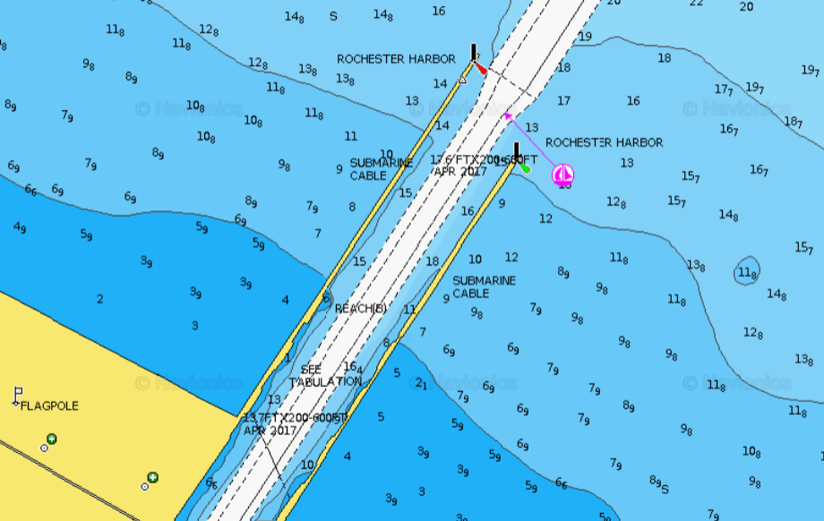
Looking at depth charts and I dont understand. whats the deal with the big number with the little number next to it? it confuses and angers me.
 adamftw
> itschrome
adamftw
> itschrome
09/05/2018 at 10:51 |
|
Whats the chart say for depth format? It should be labeled “soundings.” I’m going to assume its fathoms and feet, 6 fathoms 9ft; 3 fathoms, 9 ft, etc.
1 fathom = 6ft, btw.
 Aremmes
> adamftw
Aremmes
> adamftw
09/05/2018 at 10:57 |
|
That looks like a Navionics chart, so the depths are shown in whatever unit the user chose (feet/inches by default). I’m quite certain that those are feet and inches — their
webapp
confirms it.
|
itschrome
> Aremmes
09/05/2018 at 11:00 |
|
it is and it’s in feet. but I cant find out what the little numbers mean
 HammerheadFistpunch
> adamftw
HammerheadFistpunch
> adamftw
09/05/2018 at 11:00 |
|
My guess as well.
 OPPOsaurus WRX
> adamftw
OPPOsaurus WRX
> adamftw
09/05/2018 at 11:00 |
|
if one fathom is 6' why would you put 5f- 9' and not 6f- 3'
 benjrblant
> itschrome
benjrblant
> itschrome
09/05/2018 at 11:04 |
|
I’d guess high and low tide?
Edit: Oh, I see that it’s a lake. Nevermind.
 functionoverfashion
> itschrome
functionoverfashion
> itschrome
09/05/2018 at 11:08 |
|
I believe that’s meters and tenths.
Could be fathoms and feet, except that there are numbers higher than 5, which wouldn’t make sense. Must be meters.
|
Aremmes
> itschrome
09/05/2018 at 11:08 |
|
The subscript
numbers are inches.
|
functionoverfashion
> itschrome
09/05/2018 at 11:09 |
|
little numbers would be inches, although I would think it would be meters and tenths of meters, as there are no numbers above 9 there. could be coincidence
|
functionoverfashion
> OPPOsaurus WRX
09/05/2018 at 11:10 |
|
Must either be meters/tenths or feet/inches then...
 Akio Ohtori - RIP Oppo
> Aremmes
Akio Ohtori - RIP Oppo
> Aremmes
09/05/2018 at 11:11 |
|
Oddly specific. I would have expected the margin of error to be large enough that inches would be irrelevant.
|
itschrome
> benjrblant
09/05/2018 at 11:11 |
|
there is a mild tidal effect on the lake, not enough to go from 12 f eet to 8 feet tho...
|
itschrome
> functionoverfashion
09/05/2018 at 11:12 |
|
nah it’s set for feet. the area around the piers run up to shore so fathoms wouldn’t work too well in that shallow of water.
|
Aremmes
> Akio Ohtori - RIP Oppo
09/05/2018 at 11:18 |
|
I agree, but that’s how Navionics rolls. They have a program in which users can submit chartplotter/fishfinder
sounding data that is arguably more precise than what NOAA/USCG have used in the past, and they're probably not normalizing the data.
 cbell04
> itschrome
cbell04
> itschrome
09/05/2018 at 11:21 |
|
Relevant. Winter surfing during a snow storm right at that spot. Crazy folks.
|
functionoverfashion
> itschrome
09/05/2018 at 11:24 |
|
Ah, then feet and inches it is.
|
itschrome
> cbell04
09/05/2018 at 11:25 |
|
yeah.... No thank you! hahaha people are insane!
|
adamftw
> OPPOsaurus WRX
09/05/2018 at 11:33 |
|
Oh yea, makes sense.
|
itschrome
> functionoverfashion
09/05/2018 at 11:35 |
|
ok, I’ll buy that. just seems odd to list inches.
|
functionoverfashion
> itschrome
09/05/2018 at 11:36 |
|
I totally agree. But it’s consistent with using fathoms/feet, meters/tenths...
|
functionoverfashion
> Akio Ohtori - RIP Oppo
09/05/2018 at 11:37 |
|
For sure it is, but it’s consistent with using fathoms/feet, or meters/tenths. If you
really
want your depths to show in feet, they’re still giving you the next level of detail whether it’s significant or not.
 asenna
> cbell04
asenna
> cbell04
09/05/2018 at 13:37 |
|
Its feet a nd tenths of feet not inches. i.e 10.8ft
 You can tell a Finn but you can't tell him much
> itschrome
You can tell a Finn but you can't tell him much
> itschrome
09/07/2018 at 15:50 |
|
Comparing it to the NOAA chart for Rochester I would guess that it is giving the depth in feet and tenths of feet. A little bit odd for a UOM, but feet-inches doesn’t seem to make sense either since there are not subscripts higher than nine. The NOAA chart is available here: http://www.charts.noaa.gov/PDFs/14815.pdf
I found that particular chart through their chart locator here: http://www.charts.noaa.gov/InteractiveCatalog/nrnc.shtml#mapTabs-1
|
itschrome
> You can tell a Finn but you can't tell him much
09/07/2018 at 15:54 |
|
awesome! thank you. thats a sweet chart!