 "Smallbear wants a modern Syclone, local Maple Leafs spammer" (smallbear94)
07/13/2016 at 09:59 ē Filed to: None
 0
0
 14
14
 "Smallbear wants a modern Syclone, local Maple Leafs spammer" (smallbear94)
07/13/2016 at 09:59 ē Filed to: None |  0 0
|  14 14 |
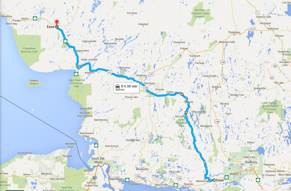
...Not that thereís nothing to do, but Iím stuck waiting for other people before I can do anything with it. So I sit here plotting gas station hops for this summers road trip, when...

https://www.google.ca/maps/dir/Esso/Ö
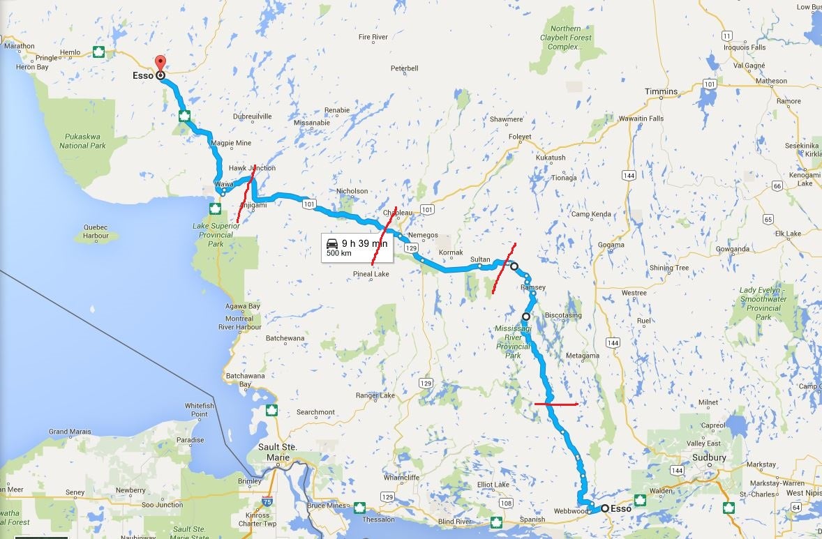
...yeah, no. No way thatís a 9h39m stretch. That works out to an average speed of 51.81 km/h.

If I divide the run into 5 roughly equal stages I can get a better idea of how far off this is. 5 sections multiplied by a 51.81 km/h average gives me a total of 259.05. From this I can begin deducting the speeds I expect to travel (OK, weíll stick to speed limits for the sake of the argument). From the top left and working back, thatís about 89 (2 limit areas), 80, 80, 63 (2 limit areas), 60 afaik. The last 2 might both be 70. Doesnít really matter, because after taking off the first 3, Iím left with 10.05, and dividing that between the two remaining sections gives me 5.025 km/h as what google expects me to average on that stretch.
Going by conservative numbers, Iíd count on averages of 95, 90, 90, 65, 55 for each of those sections based on normal Ontario traffic. So, (95+90+90+65+55)ų5= 79 km/h average. 500kmų79= 6.329h, or about 6h20m. throw in a half-hour lunch stop and I should still beat googleís time by nearly 3 hours.
I love it when google is wrong. Place your bets, oppo, how much can I beat it by?
 Stapleface
> Smallbear wants a modern Syclone, local Maple Leafs spammer
07/13/2016 at 10:07 |
|
Maybe Google can see into the future and know there will be traffic along the way? That time estimate does seem way off though. My Google maps estimates are usually almost exactly on the button.
 Smallbear wants a modern Syclone, local Maple Leafs spammer
> Stapleface
07/13/2016 at 10:12 |
|
Yeah, all the other legs seem pretty close. Maybe 5-10 minutes slow over 4 hours.
I do genuinely want to know whatís up tho. Maybe because theyíve never been up that road with the streetview car? Would they take speed readings from the streetview car?
 Stapleface
> Smallbear wants a modern Syclone, local Maple Leafs spammer
07/13/2016 at 10:17 |
|
You would think it would go by what the posted limit is? Or if there is no posted limit perhaps it just assumes its 25 mph?
 bob and john
> Smallbear wants a modern Syclone, local Maple Leafs spammer
07/13/2016 at 10:18 |
|
wait your in canada? huh
 GhostZ
> Smallbear wants a modern Syclone, local Maple Leafs spammer
07/13/2016 at 10:22 |
|
I wonder if it automatically lowers the speed if the road turns. So Ďwindyí roads end up never picking back up to highway speeds.
 Smallbear wants a modern Syclone, local Maple Leafs spammer
> Stapleface
07/13/2016 at 10:26 |
|
So would I, but Google obviously realises thatís horseshit. On the 90km/h roads up here on the other legs it shows an average 92-95km/h. besides, like I said using the posted limit for an average (and even using 25mph for the small roads) still beats their estimate by a solid margin.
 Smallbear wants a modern Syclone, local Maple Leafs spammer
> bob and john
07/13/2016 at 10:26 |
|
Correct.
 Out, but with a W - has found the answer
> Smallbear wants a modern Syclone, local Maple Leafs spammer
07/13/2016 at 10:26 |
|
Is the Southern part (810) unpaved? Because itís indicated as a small grey line in GMaps, so itís possible that it assumes a low speed limit.
 Smallbear wants a modern Syclone, local Maple Leafs spammer
> GhostZ
07/13/2016 at 10:26 |
|
Or maybe itís calculating the time Iíll spend getting lost :)
 Smallbear wants a modern Syclone, local Maple Leafs spammer
> Out, but with a W - has found the answer
07/13/2016 at 10:30 |
|
I donít believe 810 is paved, but this doesnít actually take me on 810. Itís actually an even smaller road. Thereís nothing paved on this route between Webbwood and Sultan. But still, to meet itís prediction Iíd have to have a top speed of no more than 5km/h on that part. The lowest I can imaging is 30km/h.
Iím sure thatís where theyíre getting hung up, but I still canít figure why theyíd assume such a low speed.
 Out, but with a W - has found the answer
> Smallbear wants a modern Syclone, local Maple Leafs spammer
07/13/2016 at 10:42 |
|
Oh, cool! Iíd probably have to drive 500km to find more than 20km of uninterrupted unpaved road here.
Iíd guess itís an algorithm gone wrong on the limit case of small, unpaved, unknown road.
 thebigbossyboss
> Out, but with a W - has found the answer
07/13/2016 at 11:52 |
|
Where smallbear is it doesn't take all that long to get to somewhere that's about 400 kms from the nearest traffic light lol.
 Smallbear wants a modern Syclone, local Maple Leafs spammer
> thebigbossyboss
07/13/2016 at 14:22 |
|
Not to mention gas stations. The longest stretch is on this leg, 289km from Espanola to Chapleau. I intend to bypass that one. Next station is 408km from Espanola in Wawa, and depending on the gas/time situation, Iíll either be grabbing lunch in Wawa or White River. I know the food situation in White River, thereís a good A&W attached to the gas station and personally Iíd rather shoot for White River since I know exactly where to go. Even though Wawa is bigger and will have more selection, I donít want to mess around looking for it. But Iím getting off track. Point of story: 500km of road with just 2 intermediate gas stations.
And as I was typing this, a thought hit me... isnít it funny when you canít stop planning something? I sorted out what I THOUGHT were the fine details on this trip a while ago, but I canít stop myself from continuing to fine-tune everything.
 thebigbossyboss
> Smallbear wants a modern Syclone, local Maple Leafs spammer
07/14/2016 at 11:37 |
|
Same when I planned my June road trip last year to the east coast. Planning it was fun. I planned that trip out really well.
However, when I drove from Ottawa to Prince George BC I didnít plan much at all. Just picked my departure date and got rolling. It took an extra day because I got delayed by a blizzard.