 by "Rusty Vandura - www.tinyurl.com/keepoppo" (rustyvandura)
Published 09/13/2017 at 09:33
by "Rusty Vandura - www.tinyurl.com/keepoppo" (rustyvandura)
Published 09/13/2017 at 09:33
No Tags
STARS: 4
 "random001" (random001)
09/13/2017 at 09:38, STARS: 1
yowch....
 "Rust and Dust - Oppositelock Forever" (rustanddust)
09/13/2017 at 09:58, STARS: 0
Just for comparison:

 "OPPOsaurus WRX" (opposaurus)
09/13/2017 at 10:12, STARS: 5
there it is, its just been relocated
 "ttyymmnn" (ttyymmnn)
09/13/2017 at 10:56, STARS: 0
And I never made it there. :(
 "TheRealBicycleBuck" (therealbicyclebuck)
09/13/2017 at 11:01, STARS: 3
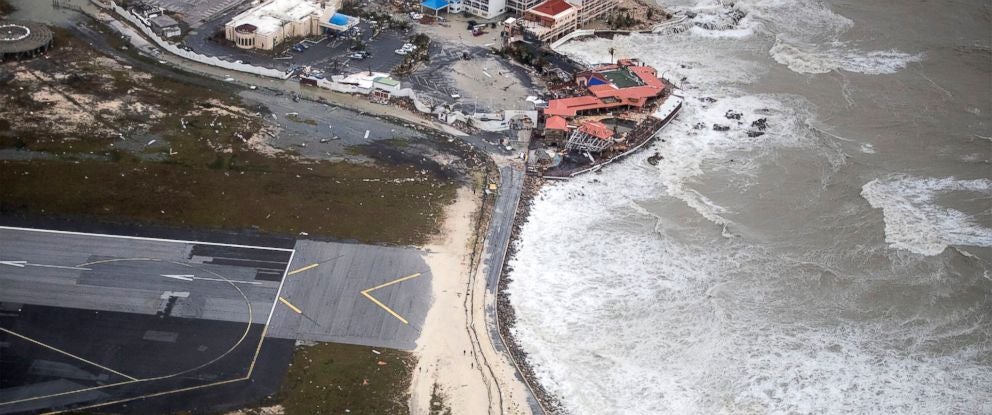
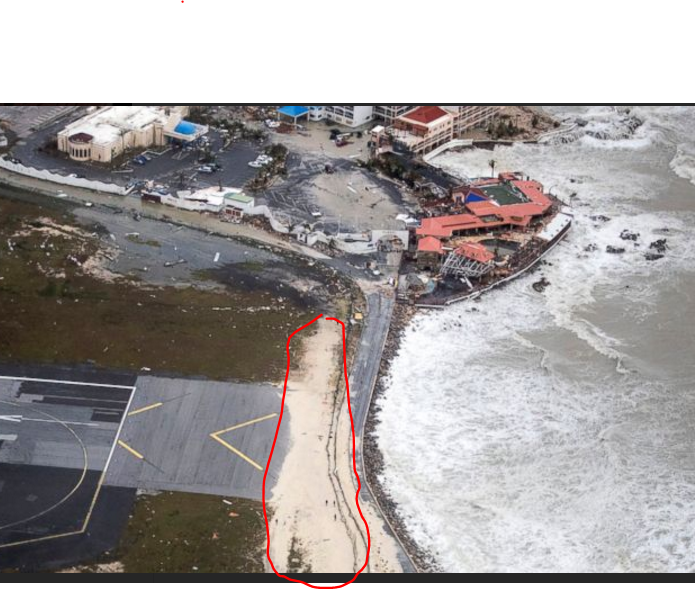
Beaches and dunes, when left undisturbed, grow during normal weather and “disappear” during storms. The mechanism is simple. Low wave action tends to move sand from offshore to the beach, then wind, through a process called saltation, moves the sand from the beach to the dunes. The energy from large waves generated by storms is absorbed by the dunes and the sand is carried back offshore by the retreating waves.
Seawalls screw this up by reflecting much more of the waves’ energy. The excess energy carries sand further offshore making it unavailable for the normal replenishing process.
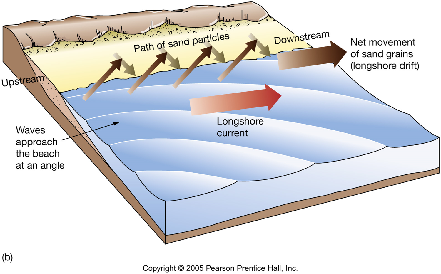
Groins (which a lot of people erroneously call jetties) screw up the longshore currents, creating strong on-shore currents which erode beaches. Galveston has some great examples of this.
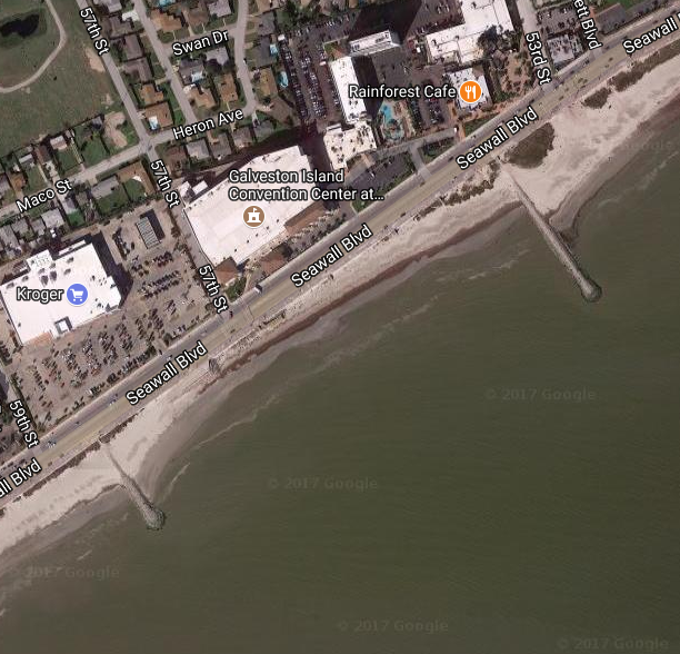
When I lived there, there wasn’t much beach to be seen along the seawall. The beach replenishment programs have done wonders. The difference in the beaches on either side of and between the groins are a reflection of the currents and the erosion caused.
Granted, most of Galveston wouldn’t be developed if not for the seawall.
 "AfromanGTO" (afromangto)
09/13/2017 at 11:19, STARS: 0
Hey good explanation. You left out long shore transport for sand, but you get the point across rather well.
 "CaptDale - is secretly British" (captdale)
09/13/2017 at 11:24, STARS: 0
Good! Now I won’t have to see new videos of that place.
"TheRealBicycleBuck" (therealbicyclebuck)
09/13/2017 at 12:15, STARS: 2
Thanks. I did leave out longshore transport. But since you mention it....
Longshore transport is the movement of materials along a shoreline with the prevailing currents. In the Gulf of Mexico, there is a longshore current that flows roughly from the Mississippi River west and south to Padre Island where it meets up with currents moving north from Mexico.
The erosion of Louisiana’s coastline is attributable to this current, but the situation is more complicated than that. The Mississippi River used to supply sediments which were picked up by these currents and carried westward, providing a constant resupply of materials. Dredging and channelization of the river have increase the flow rates, pushing the sediments into deeper water where the oceanic currents can’t carry them back to the shore. During flood events, these sediments would be carried into the surrounding swamps and marshes, providing resupply from the other direction. This process has been thwarted by the construction of levees along the entire length of the lower Mississippi. Flood water is pushed even farther into the Gulf, making the sediment loss even worse.
This process was explained in a coastal ecology course I took as an undergrad. That professor sparked my interest in broad-scale problems which led to me doing graduate work. This is why I live in Louisiana today.
"AfromanGTO" (afromangto)
09/13/2017 at 12:30, STARS: 0
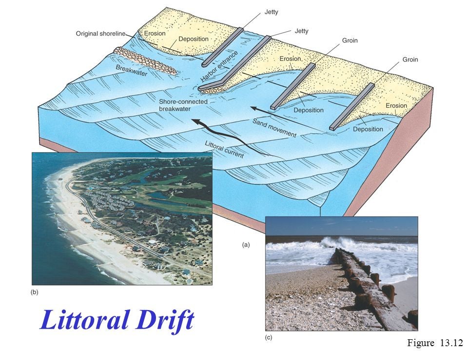
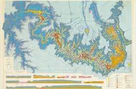
Very nice explanation! I was referring to more of longshore transport for sand such as this figure. Since we were talking about a beach moving.
I found this figure about Littoral Drift which shows how the groins mess up the beaches for your 1st description above.
Nice where did you go to graduate school? I have a degree in Oceanography.
"TheRealBicycleBuck" (therealbicyclebuck)
09/13/2017 at 13:48, STARS: 1
Thanks again. I tend to jump to broad-scale. I’m a really big picture kinda guy.
I started with a degree in Marine Biology. I wrapped up my academic career with a doctorate in Urban and Regional Science. Now I tackle problems at the watershed scale or larger.
"Rusty Vandura - www.tinyurl.com/keepoppo" (rustyvandura)
09/13/2017 at 14:31, STARS: 0
I will, if it recovers.
"Rusty Vandura - www.tinyurl.com/keepoppo" (rustyvandura)
09/13/2017 at 14:37, STARS: 0
Thank you for the explanation. I lived in Louisiana for several years in the 80s, stationed at Fort Polk. Other than your purposes, I do not readily think of good reason to live in Louisiana. Along the same lines, and really not wishing harm on actual humans, I would not have minded seeing the Leeward Island Irma Treatment applied to the state of Florida.
Here is a story about Florida that I enjoyed very much:
http://www.politico.com/magazine/story/2017/09/08/hurricane-irma-florida-215586
"Rusty Vandura - www.tinyurl.com/keepoppo" (rustyvandura)
09/13/2017 at 14:38, STARS: 2
Interesting stuff. I’d have been curious to see Irma give the Leeward Islands treatment to the state of Florida, except lots of dead people.
Here is a story about Florida that I enjoyed very much and I bet you would also:
http://www.politico.com/magazine/story/2017/09/08/hurricane-irma-florida-215586
"TheRealBicycleBuck" (therealbicyclebuck)
09/13/2017 at 14:51, STARS: 2
Louisiana is here because of commerce - specifically the Ports of New Orleans and Baton Rouge and the Mississippi River.
Once you get north of the coastal zone, the delta is a fine place to farm. We just have a little too much arrogance and work way too hard to keep the Mississippi in its banks. If not for our intervention, the Mississippi would have shifted over the the Atchafalaya basin years ago.
One of my favorite maps is of the Mississippi River Meander Belt.
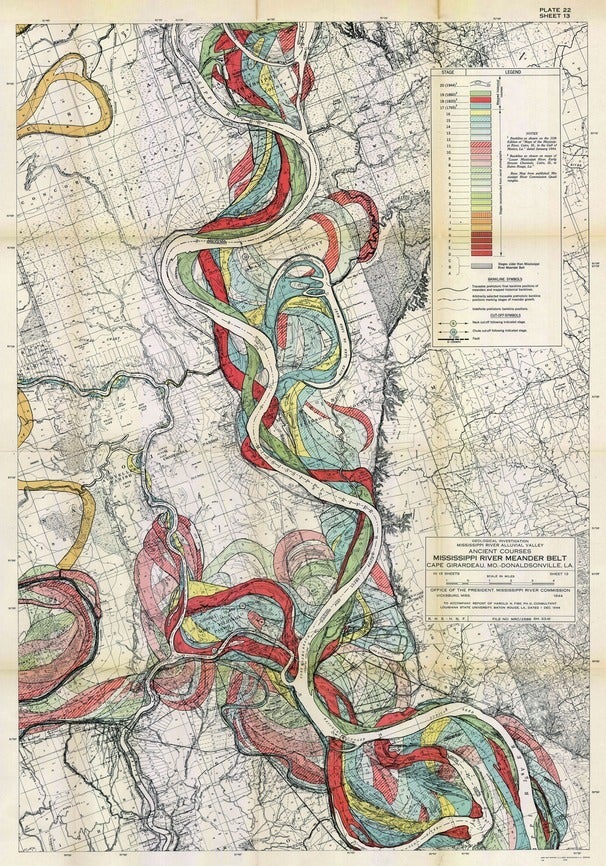
It shows many of the historical courses of the river.
Our approach to the river should be more like the ancient Egyptian’s approach to the Nile. When the floods came, they were welcomed. They renewed the land.
Beyond that, I find that Louisiana is much like any other place. People are people. Places are places. Look closely enough and there’s always something interesting to see.
"AfromanGTO" (afromangto)
09/13/2017 at 15:05, STARS: 0
That’s awesome!! Congratulations on earning those degrees!
"AfromanGTO" (afromangto)
09/13/2017 at 15:47, STARS: 0
That’s a great article! It’s very ironic since I moved from Miami Beach to Orlando in July.
"TheRealBicycleBuck" (therealbicyclebuck)
09/13/2017 at 16:00, STARS: 1
So, what kind of work are you doing with your degree? I thought about a master’s in Oceanography until the day I decided I really didn’t want to be a marine biologist any more. On that cold January morning, I was up to my armpits in a wetland trying to retrieve the sample plates from one of our experiments. It was then I knew that I didn’t want to be doing this for the rest of my life. Outdoors is fine. Freezing my ass off and soaked to the bone, no thanks.
"AfromanGTO" (afromangto)
09/13/2017 at 16:10, STARS: 1
I did mitigation and permitting projects in school. That really interested me. I didn’t want to be out in the marsh measuring oysters or collecting toad fish. A lot of the projects that I did in school dealt with developers wanting to build and have as minimal impact as wetlands as possible. So from that I got into real estate, and it has actually helped me a great deal. Much to mine and others surprise.
"TheRealBicycleBuck" (therealbicyclebuck)
09/13/2017 at 16:27, STARS: 1
Interesting coincidence! Real estate/Land development was what I did for my master’s. I work as the middle-man between the environmentalists (marine biology), the developers (my master’s), and local/state/federal governance (my doctorate). One of the biggest problems I saw was a lack of understanding between the three groups, most of it because of differing goals. My education put me in a place where I can work with a variety of federal, state, and local agencies, mostly as a consultant. It’s fun and challenging work when we’re busy.
"AfromanGTO" (afromangto)
09/13/2017 at 16:40, STARS: 0
That’s freaky! It sounds like you had a fun project on your hands. It must have been satisfying to know that when they started the project you started you masters, and the project most likely finished around the time you got your doctorate. Lack of understanding between developers, govt, and scientist? Never had I heard such of a problem before. lol It really surprised me how much of the Corps of Engineers paid attention to what people did, and how they tried to keep companies from messing up wetlands. I know to never mess up salt marsh, but I would love to start up a mitigation bank one day. If the govt didn’t have that hiring freeze, I’d be working for the corps right now, but real estate is fun too.
"TheRealBicycleBuck" (therealbicyclebuck)
09/13/2017 at 16:49, STARS: 1
I was fortunate to be in school with a professor who was on the cutting edge of mitigation banking. I’m not sure if he cared more about the environment or the money that could be made. Half our classes were doing things like wetland delineation and the other half were working on financial costs for developing the banks. Not long after I graduated, he left the university and went into the mitigation banking business full time.
Different corps offices have different focuses. Down here it’s all about coastal restoration and levees.
"Rusty Vandura - www.tinyurl.com/keepoppo" (rustyvandura)
09/13/2017 at 17:13, STARS: 0
Cup half full is a good perspective to have.
Do you know where I could get a poster-sized copy of that meander or a high-res JPEG?
Did you look at the Florida article?
"Rusty Vandura - www.tinyurl.com/keepoppo" (rustyvandura)
09/13/2017 at 17:20, STARS: 1
I love the colorful historical quotes. I’ve never been a fan of Florida, but I always thought it must be all that, particularly since the highest point in the state is only 3 feet above the lowest point, as I understand it.
"Rusty Vandura - www.tinyurl.com/keepoppo" (rustyvandura)
09/13/2017 at 17:28, STARS: 0

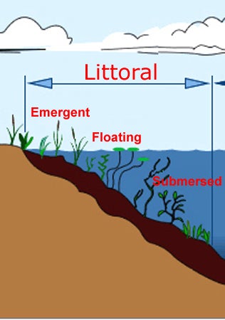
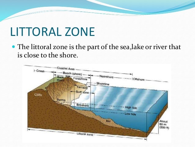
This is where I’d previously seen the word
littoral
. How do you suppose the word connects to the ship? Because beach landing?
"TheRealBicycleBuck" (therealbicyclebuck)
09/13/2017 at 18:34, STARS: 1
You can get copies of the original plates from USACE. http://lmvmapping.erdc.usace.army.mil Prints are also available from Amazon. Look for Harold Fisk, 1944.
Part of my background is in disaster response and recovery, so I’m somewhat familiar with the story about how Florida was developed and the disaster response after Andrew. That article filled in some gaps, but left lots of others open.
Funny thing, though, is that one of my ancestors fought in the Seminole Indian wars in Florida. He was later stationed in New Orleans, not far from where I live.
"TheRealBicycleBuck" (therealbicyclebuck)
09/13/2017 at 18:39, STARS: 1
Littoral means near or on the shore. Those ships were designed for near-shore shallow water operations.
 "TheHondaBro" (wwaveform)
09/14/2017 at 02:57, STARS: 0
I hate it when the seawater dissolves my groin.
"TheRealBicycleBuck" (therealbicyclebuck)
09/14/2017 at 08:15, STARS: 0
Keep it in your pants and there’s less chance it will erode.
"AfromanGTO" (afromangto)
09/14/2017 at 11:30, STARS: 0
My professor was the same way. We may had did the same projects. It was extremely interesting to me. A few months after the class was over he received a promotion and became the head of a much larger district for the corps.
In my area when I went to school the focus was primarily salt marshes, and how not to destroy them.
"AfromanGTO" (afromangto)
09/14/2017 at 11:35, STARS: 0
Me too! But I grew up in areas fairly rich in history. I grew up on this island
https://en.wikipedia.org/wiki/St._Simons%2C_Georgia.
That actually isn’t true. Where I work it is fairly hilly. From wiki: “Elevations range from 20 feet (6.1 m) to 112 feet (34 m) above sea level.”. There’s even signs that says Danger Hill limits visibility.
"AfromanGTO" (afromangto)
09/14/2017 at 11:48, STARS: 1
Most likely the ship operates in or near the littoral zone.
"TheRealBicycleBuck" (therealbicyclebuck)
09/14/2017 at 12:05, STARS: 1
Salt marshes and bay ecology were the primary focus of my undergrad program. It’s one of the reasons I decided not to follow that career path. Marshes are interesting, but I really wasn’t expecting my entire degree program to be focused on them. One of my professors was researching the physical parameters of existing marshes so they could do a better job of designing new ones. He had us planting test plots of spartina so he could see how different slopes and water depths affected growth rates. I wasn’t happy. I was fascinated by coral reef ecology, not plants in muck. Jacques Cousteau is to blame.
It was funny that it all came up again in my master’s program. Back then, they were still figuring out the rules and debating about whether or not the bank had to be within the same watershed, what mitigation ratios were appropriate, etc. I found myself once again mucking around in wetlands. I wasn’t happy about it, but being the lone marine biologist in the program, I was able to provide a lot of insight.
"Rusty Vandura - www.tinyurl.com/keepoppo" (rustyvandura)
09/14/2017 at 14:24, STARS: 1
There was once a website, that may still exist, that aggregated stories from around the web — mostly ridiculous stories — and categorized them into buckets like stupid driver, ditzbrain female, or whatever. Florida had its own category, simply,
Florida
.
 "gmporschenut also a fan of hondas" (gmporschenut)
09/15/2017 at 00:22, STARS: 0
There was in intesting article from a civil engineer who submitted a report back in May to Houston may 2015 floods, and those of last spring that those were dire warnings that all the sprawl was negating any improvement in drainage. Also the FEMA maps (in their own publishing) were at best optimistic as the spawl would substanially require them to be reevaluated.
The calls for “we’re going to rebuild (in the exact same spot and same floorplan)” need to be told “fine, but your on your own”.
The idea of increasing major metropoli in coastal areas prime for a major diaster is nuts.
"Rusty Vandura - www.tinyurl.com/keepoppo" (rustyvandura)
09/15/2017 at 00:39, STARS: 0
I wanted to see a Category 5 scouring of Miami a la St. Maartens.
"gmporschenut also a fan of hondas" (gmporschenut)
09/15/2017 at 07:36, STARS: 0
thats cold.
"AfromanGTO" (afromangto)
09/15/2017 at 10:24, STARS: 0
I do not doubt that at all. I think several websites have their own FL dedicated sections. lol
"AfromanGTO" (afromangto)
09/15/2017 at 10:59, STARS: 0
Oh
spartina
, that was discussed so much in my program. Salt marsh ecology is one subject that never really interested me either. A discussion about the oceanic conveyor belt yes, or how the increasing nitrification of the ocean increases jelly populations of course. But wading around in the muck and recording different grids, I can do without. You got to do all the fun work with mitigation banks. That’s one topic I have yet to hear discussed on the news.
"TheRealBicycleBuck" (therealbicyclebuck)
09/15/2017 at 11:21, STARS: 0
The fun part was watching them wrangle over the definition of a controlled wetland. The area under discussion was formerly a rice field. The owners decided to stop farming it and let it go natural. They built a big hunting lodge and started managing the property for waterfowl. When the ideas came up for mitigation banking, it created a win-win situation for the landowners. They could turn it into a bank and still manage it for waterfowl.
The fight was over whether or not it should be considered an existing wetland and subject to the current laws protecting wetlands. It all came down to how water got onto the land and how water was kept on the land. In other words, it came down to a valve.
Since the water level was controlled by a single valve on a single pipe at the lowest part of the land, they finally agreed that the whole system was a construct, subject to the whims of the property owner. Being under the control of the owner and not subject to federal wetland regulations, the agencies finally agreed that the land would qualify.
That case determined many of the guidelines for distinguishing between existing and managed wetlands.
Since you’re interested, you might like this news article about mitigation banks and politics in Texas: http://www.houstonchronicle.com/news/houston-texas/houston/article/Banking-on-Texas-wetlandsSome-6516745.php
"AfromanGTO" (afromangto)
09/15/2017 at 12:36, STARS: 1
That sounds like something I would have liked to stay out of. I like the idea of creating a mitigation bank since they already managed it for waterfowl. In the end I’m glad the owners were able to do what they wanted with their land.
That was a very interesting article. It is interesting how he kept the mineral rights and mined for oil and gas. Fracking however kind of seems to defeat the purpose of a mitigation bank, and create a pristine wetland.
"Rusty Vandura - www.tinyurl.com/keepoppo" (rustyvandura)
09/15/2017 at 14:22, STARS: 0
Did you see this story? We shouldn’t be living there.
http://www.politico.com/magazine/story/2017/09/08/hurricane-irma-florida-215586
But yes, it’s pretty cold. I would want to see everyone evacuated before the storm arrived so nobody got hurt.
"Rusty Vandura - www.tinyurl.com/keepoppo" (rustyvandura)
09/15/2017 at 14:22, STARS: 0
What are some others of your favorite maps?
"Rusty Vandura - www.tinyurl.com/keepoppo" (rustyvandura)
09/15/2017 at 14:27, STARS: 1
Fark.com
"TheRealBicycleBuck" (therealbicyclebuck)
09/15/2017 at 16:12, STARS: 1
Hands down, the Geologic map of the eastern part of the Grand Canyon National Park, Arizona . I bought this map when I visited the canyon as a young undergrad and it graced the walls of every abode until I got married. I still have it stored away in the attic.
"gmporschenut also a fan of hondas" (gmporschenut)
09/15/2017 at 19:44, STARS: 0
Oh i agree. The idea of allowing massive building in a areas thatis consistantly floods is beyond logic.
there was a st loius newspaper that ran an even more damning article on how all the building has fundementally changed the hydrology and that Houston officials have been warned year after year that they need major re-evaluation of how the region would flood.
http://www.slate.com/blogs/the_slatest/2016/06/03/historic_floods_in_houston_texas.html
the idea that this happens every couple years, and people just rebuild on the same spot is beyond insane.