 by "SVTyler" (svtyler)
Published 04/30/2017 at 16:45
by "SVTyler" (svtyler)
Published 04/30/2017 at 16:45
No Tags
STARS: 0
The plan is to rent some sports/fun cars off Turo (so far the two top contenders are a 500 Abarth and NC Miata) and spend the day on as many amazing driving roads as we can find on our way up to Cleveland National Forest for some hiking. The problem is we’re only renting these cars for the day which means there’s a 200mi limit unless we want to pay 75cents/mi for overages, so we’re trying to be efficient as possible in hitting as many roads as we can.
As the resident car guy of the group I was tasked with finding the route. Here’s what I got so far, any suggestions?
 "Toby F., Manager" (itsmefromhr)
04/30/2017 at 17:19, STARS: 1
When you’re on the 79 be careful of not only animals, but also other drivers who cut into opposing lanes. I’ve heard of too many crashes that have occured on that stretch.
Also, the further you get up that route, you should know that cell/gps signal lacks and/or becomes non existent in many parts.
You’re from LG?
"Toby F., Manager" (itsmefromhr)
04/30/2017 at 17:22, STARS: 1
"SVTyler" (svtyler)
04/30/2017 at 17:39, STARS: 0
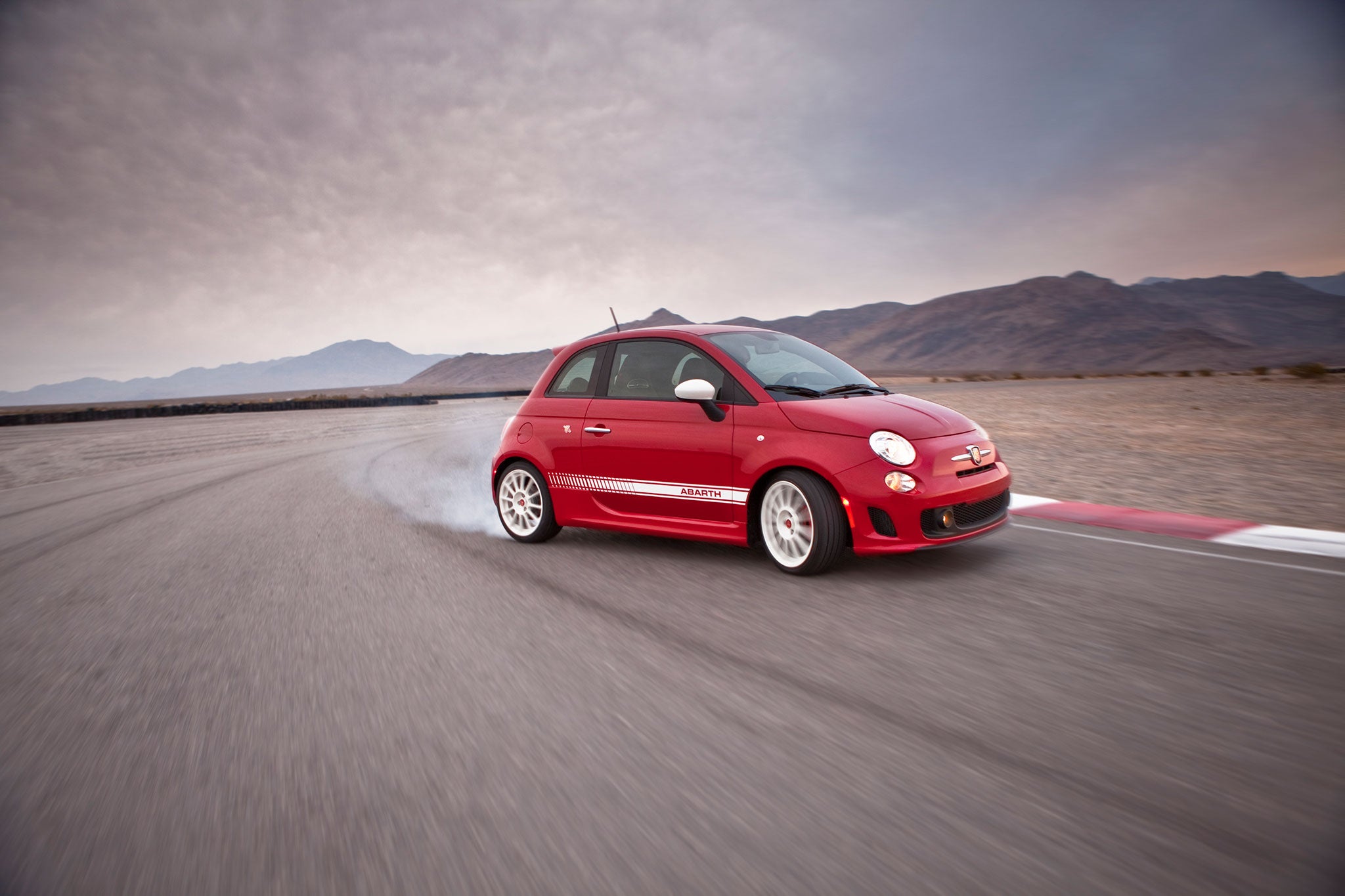
We’ll definitely keep both those in mind, both of the drivers (me and another dude) agree the main goal of the trip is to avoid as much risk as we can and instead treat this as a scenic drive rather than a backroads run. Actually that’s why we’re getting the Abarth and Miata, they were two of the slowest cars we could find. Not that we’d do anything stupid in something faster, we were just looking for cars that could be enjoyed at lower speeds instead of needing to be flogged like an M4 or Cayman, which were the other two we were considering.
We planned on downloading the route to our phones beforehand just in case but as far as cell phones go I’m hoping we won’t need them in case of emergencies. One of the guys has been out there before on several hiking trips so he knows the area pretty well, as well as the roads we’re taking and he thinks that’ll be enough so I’m trusting him on that.
I’m actually from Indiana of all places but visiting a friend who lives in San Diego (one of the cars we’re renting is in Lemon Grove which explains the route). He’s going back to school here at Purdue next semester so we figured that gives us an excuse to make the trip out to enjoy SD before he moves back.
Thank you for the response.
"SVTyler" (svtyler)
04/30/2017 at 17:41, STARS: 0
Thanks for this, I’ll send that to our other driver. I’ve Streetviewed a lot of the route (especially the sketchy parts) to get an idea of what they look like and what conditions we can expect but this is the kind of thing we’d never know about. We’re hoping to go during the middle of the week when traffic’s at a minimum and the sun has been out so hopefully we won’t have any problems.
"Toby F., Manager" (itsmefromhr)
04/30/2017 at 18:10, STARS: 1
It should also be noted that we’re currently in Santa Ana season, meaning higher temperatures (it is 90 today where I’m at, and I live closer to the coast than the mountains), high gusts of winds, and higher risks of wildfires. Bring plenty of water, plan your evac routes, ensure the car is in good working order, be wary of being blown around in smaller cars, and avoid anything that may cause fires. It may help to inform others of your whereabouts, ETA, and have a small “get home” bag of snacks and general first aid.
"Toby F., Manager" (itsmefromhr)
04/30/2017 at 18:19, STARS: 1
Sorry, another thing. Make sure you top off. I don’t think there are any stations on the mountain or on the route
"SVTyler" (svtyler)
04/30/2017 at 18:45, STARS: 0
All great suggestions, thank you, I’ve never hiked in an area like this so any information I can get on it is extremely helpful. My friend is a pretty experienced hiker so I’m sure he’s already aware of these kinds of safeguards but I’ll make sure he does just in case. Didn’t even consider the winds blowing around a smaller car (especially something tall like the Abarth), all the more reason to drive a bit more carefully I guess. A bit of research seems to indicate the winds themselves aren’t too bad once you get within the forest where the trees can block a lot of it but we’ll definitely keep all that in mind.
"SVTyler" (svtyler)
04/30/2017 at 18:48, STARS: 0
Seems like there’s a small Ramco station in Julian, which is where we’re stopping for lunch, so we should be good on that front. Seems to be the only one in the area so thanks for that, we didn’t even consider there wouldn’t be a station or two along the way. Good to know there is one.
 "Z (ND + Cancer Fighter)" (roadsterzach)
04/30/2017 at 18:52, STARS: 1
That gas station in Julian is notoriously overpriced all the time since its the only one up there, by the way. Last time the girlfriend and I were in the area they wanted $4.50 for standard 87 when the going rate in North County was average like $2.65.
"Z (ND + Cancer Fighter)" (roadsterzach)
04/30/2017 at 19:03, STARS: 2
I was going to suggest Palomar Mountain as a must since it is
so much fun and worth the drive
, but I finally got Google to load the map and see it’s your ending point, so nice!
Some advice though, but it looks like you are going up East Grade and coming down South Grade - don’t. South Grade is absolutely miserable to drive down because you can’t push it, are trying to not cook your brakes while constantly switching between 1st and 2nd for engine braking - and if you go on a weekend, the motorcycles are awful.
I always suggest going up South Grade, where you can actually push it a little, have so much more fun and enjoy the nice drop down East Grade.
Also, not sure what you’re doing for food at the end by Palomar, but at the 4-way cross where the various grades meet is a small tourist shop and Mother’s Kitchen where you can get an amazing breakfast (their lunch is alright) and at the end of East Grade where it meets the 76 is Round-up BBQ which is to die for taste wise and massive portions for the price.
Also, for renting cars off Turo, if there is a 200 mile limit, don’t be afraid to reach out to the seller and see if they are flexible. I have a friend who rents cars there all the time and he’s often able to get an extra 50-100 miles at little or no cost just by asking.
"SVTyler" (svtyler)
04/30/2017 at 19:25, STARS: 0
You are the exact person I was hoping would see this, your post was the inspiration for our trip! Thanks for the ‘up South Grade Rd’ suggestion, the only reason we were going to do East then South was to conform to the mileage limit as doing the 76-South-East loop added nearly 10mi, though if the renters are cool with it asking for a extension that would work perfectly, especially if the drive is better in that direction. We plan on going during the middle of the week and and arriving at the trails early in the day so if your post is anything to go by traffic should be extremely light.
As far as food goes the plan is (so far as I’m aware) to get breakfast in SD, lunch up near the mountain (maybe at Mother’s Kitchen which is what my friend also recommended, though it seems like there’s plenty of places in Julian), and dinner is kind of up in the air at this point since we weren’t sure about which trail we were taking and how long the hike would last. I’ll add Round-Up to the list though, might be able to save that one for dinner since we probably won’t want to be hiking around with a BBQ food baby lol.
Do you mind if I come back to you with any questions about the route or area here in the next few weeks? Our trip starts the 20th so we have a bit more to figure out and while my local friend’s been up to Palomar Mountain a few times, he’s never actually driven the roads himself so any info on them would be invaluable.
"SVTyler" (svtyler)
04/30/2017 at 19:28, STARS: 0
Jeez, nevermind then. Seems like there’s another one in San Ysabel so we’ll have to stop there. I’ll be driving the Abarth which takes premium so as little gas price-gouging as I can find would be ideal.
 "t0ast" (t0ast217)
05/01/2017 at 12:29, STARS: 1
I’m not native to the region, but have driven that route a few times on a few different visits, including a particularly memorable one a few years ago that involved a rented Elise and witnessing a group of latest-gen Camaro test mules running in the area. The rental wasn’t through Turo, but I blew through a similar mileage limit and just kept going because it was entirely way too much fun.
I’d have to agree 100% with ZR on the Palomar directions. Up South and Down East is by far the optimal route, plus East has a scenic viewpoint near the end, which is a great place to take a break (and photos ) afterwards if you want. I went mid-day during a weekday and encountered very little traffic, plus the cars I did encounter were usually pretty good about pulling over to let me pass.
I haven’t had a chance to eat at Mother’s Kitchen yet, but Julian is definitely worth consideration if you like apples, as their pies and namesake hard cider brand are both extremely tasty IMO. I usually like to grab some of both to-go on my way out of the area.
"SVTyler" (svtyler)
05/01/2017 at 17:26, STARS: 1
Oh man, an Elise on these roads must’ve been an absolute blast,don’t blame you one bit for going over the mileage limit. I think now the plan is to go up South Grade and down East, then turn around and go back up East to get to the hiking spot at the end of State Park Rd so the viewpoint would be a great turnaround place without having to get back on 76. Should be within our mileage limit still if we go home on 15, which would mean going down South Grade but I imagine after hiking all day we’ll be too tired to push the cars at all.
Keep hearing about Julian’s apples so we’re definitely planning to stop there and get a pie or jug of cider or something, almost everyone who lives in the area that I’ve mentioned this trip to has told me we have to get
something
so I have high expectations for it lol. Thanks for the info man, we were a little unsure about the route and what to expect so having so much input from people who’ve actually been up and down the mountain is super helpful.